
Crystal clear water and breathtaking views is not everything that Lake Maggiore has to offer (read about things to do around Lake Maggiore in my previous post). Mountain and outdoor lovers are sure to be impressed by trekking opportunities in the surrounding web of the Ossola Valleys. The magnificence of the mountains, the traces of ancient and rural settlements, the cuisine excellence and the numerous trekking opportunities make Ossola Valleys and Lake Orta the perfect spot for an active vacation. I enjoyed this spectacular range of valleys in June 2019 thank to the invitation of the Distretto Turistico dei Laghi. This is the second of the three blog posts describing my trip (link to post one, and post three)
Ossola Valleys: Magnificent Mountain Peaks for Trekking Lovers
The Ossola Valleys is a leaf-shaped complex of Alpine valleys in the northern tip of Piedmont bordering with Switzerland. Seven valleys make up the area (Vigezzo, Antigorio, Divedro, Formazza, Anzasca, Antrona, Bognanco) and resemble the shape of a maple leaf from above. The valleys are within an easy reach of Lake Maggiore, as well as Milan and Turin.
The majestic mountain chain that the Ossola region is most proud of is the Monte Rosa complex. With an elevation of 4,634 meters, Monte Rosa is the second highest peak in Europe after the Mont Blanc. The town of Macugnanga, a common start point for all Monte Rosa massif hikes, can be reached from Lago Maggiore in less than two hours. But we leave the challenging trekking to the enthusiasts and head for a beautiful family-friendly hike in Alpe Devero National Park in one of the Ossola Valleys.

Village of Ai Ponti, Alpe Devero National Park, Piedmont
Alpe Devero National Park: Trekking in Ossola Valleys Between the Alps and the Lake
After spending a night in Domodossola, the valley’s geographical and administrative center, we head into the heart of national park Alpe Vegila-Devero. Vegila, the first national park in the Piedmont Region (est. 1978) was consolidated with the Devero in 1995. The park covers 86 square kilometers characterized by a typical alpine environment ranging in altitude from 1,600 to 3,500 meters.

On our way to Lake Devero, Alpe Devero National Park, Piedmont
We park in a village of Ai Ponti and walk up a beautiful cobble stone main street to the 12th century Oratory of San Bartolomeo. After admiring the view of surrounding valleys and mountain peaks, we cross the small bridge over the wild waters of Rio Buscagna. The path is easy and wide with a mild constant elevation gain, identified as “un percorso per tutti”, which means “for everyone”. As we walk, the landscape along the path becomes shadier, surrounded by the trees with isolated traditional stone houses appearing suddenly, almost by magic, along the path.
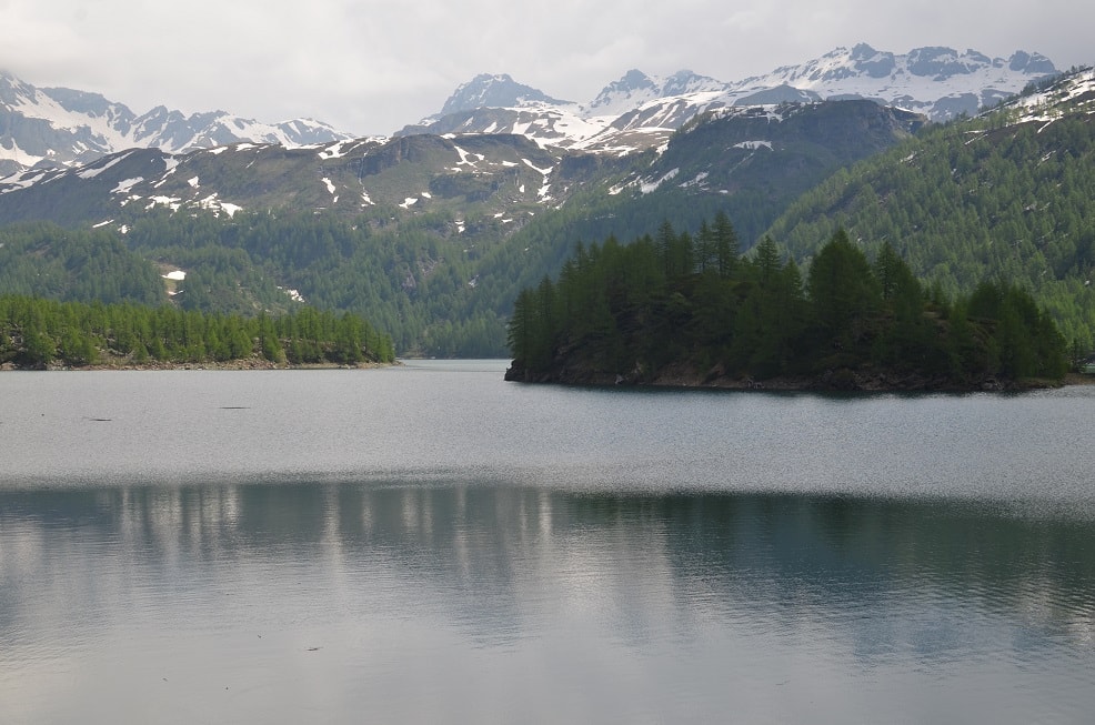
Crystal clear waters of Lake Devero in Alpe Devero National Park, Piedmont
Lake Devero
After about 40 minutes of walking we reach the village of Crampiolo, where we would stop on our way back for a tasting of some cheeses specific only to this region (read about the cheese in my report about slow food around Lake Maggiore). There are beautiful edelweiss flower and blueberry bushes all along the path. After another 20 minutes of walking, we reach the Dam of Codelago overlooking the turquoise waters of Lake Devero. The Codelago dam was one of the first in the Ossola region, erected betweem 1908 and 1912, thus raising the level of pre-existing lake by 20 meters.

Village of Crampiolo, Alpe Devero National Park, Piedmont
There is a possibility to extend the hike by making a round tour of the lake (another 4,5 km, 125 meter elevation, and approximately 2 hours). Our version of the hike from Ai Ponti and back is 8,5 km long, 300 meters in elevation, and can be completed in 1-3 hours. More information about the activities in the area in four languages can be found of the website of the Distretto Turistico dei Laghi.

Lago delle Strenghe or “Witches Lake”, Alpe Devero National Park, Piedmont
Witches Lake
Our last stop on the way back we make one more stop at the Lago delle Strenghe, also known as the “Witches Lake”. The lake’s emerald green waters are just amazing. There an old legend about the lake and a girl that realized the true face of human love by being lured in to the lake by the witches. Sadly, the real witch hunts also took place on the lake the late 16th century.
Tip for Lunch
Back at Ai Poini stop for lunch at Casa Fontana, a sustainable alpine lodge (for example, coconut and cork are used for thermal and acoustic insulation). At Casa Fontana try a typical alpine menu of Ossola cured meats and pickled vegetables, followed by polenta with braised meat, completed by a desert of orange blossom ice cream with hot wild blueberries from the park.
Uriezzo Gorges: a fascinating journey to the center of the earth
After an amazing lunch at Casa Fontana, we head to the Uriezzo Corges. During the short hike from the parking lot to the gorges, the summer heat is unbearable, and we look for every little piece of shade that we can find. Once we enter the gorges, the coolness of the caves and the breeze from the water that runs through the gorges is the most welcoming. The passages are narrow with metal stairs to help visitors navigate through the gorges.

Uriezzo Gorges, Ossola Valleys, Piedmont
The smell and sound of running water is everywhere and upon an exit from the gorges, there is a beautiful waterfall. This striking passage runs through the ravines where long ago a glacier used to be. During the glacier period 120,000 to 15,000 years ago, that territory was covered by a layer of ice that was estimated to be six kilometers wide and 1,000 meters thick. Then, the surface waters of the glacier melted very quickly dragging rocks and debris. This created holes and deep crevices that are nowadays open to visitors free of charge.

Waterfall upon the exit from Uriezzo Gorges, Piedmont
Lake Orta: Most Romantic Lake in Italy
Lake Orta is a hidden gem of its bigger sibling Lake Maggiore. Because it is smaller, it is often underrated or skipped during a trip to the Northern Italy’s Lake District. It is astonishing how few people – even Italians – know about the place, and that is absolutely why it is worth a visit. The lake was highly polluted from the 1920s until the 1980s due to the industrial facilities located there. In the 1990s, an environmental push banned pollution and the quality of the water was resorted. Today, it is one of the cleanest lakes in Italy.
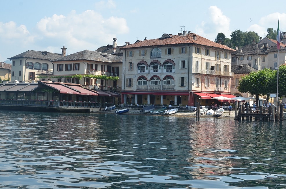
View of the Main Square of Orta San Giulio from the waters of Lake Orta
Lake Orta main town is called Orta San Giulio and is built on the slopes of a steep hill that forms a peninsula protruding out into the lake. A stop by Orta San Giulio’s Town Hall is a must. The town hall features a wonderful lakeside terrace that is open to the public and often is a place for wedding and other special occasions. It is a truly magical place where you can sit and read a good book, listen to music or just look at the lake surrounded by the mountains.

Orta San Giulio Town Hall, Lake Orta, Piedmont
In the center of the lake there is a beautiful island – Isola San Giulio. You can catch a boat to it all year around from the town square of Orta San Giulio. On the island a circular interior path leads around the vast Benedictine monastery, where about 80 nuns live year around and are the only residents of the island. In one direction, the signs along the path say “the way of silence” and in the other “the way of meditation”. The whole walk takes about 40 minutes.
Crossing on foot over a mountain: trekking from Ossola Valleys to Valsesia
On our last day in Northern Piedmont, we decided to reach our next and last destination on foot crossing over a mountain range from Ossola Valley to Valsesia. Our trekking experience starts at the old village of Campello Monti located at the elevation of 1,305 meters that still preserves unchanged to this day its Walser village charm. The Walser are the speakers of the German Walser dialect that to this day inhibit the Alps of Switzerland and Lichtenstein, along with some places in Italy and Austria (Voralberg). The village is formed by a complex of houses with pastel colors and with the typical stone roofs of high architectural quality.

Start of Trekking from Ossola Valleys to Valsesia, Village of Campello Monti on the background

Waterfalls and lush greenery everywhere along our trekking route from Ossola Valleys to Valsesia
Crossing a mountain range on foot is once in a lifetime experience. Not only you are rewarded with dramatic alpine scenery and unspoiled breathtakingly beautiful landscapes but an overwhelming feeling of accomplishment that follows is overwhelmingly rewarding. All along the route there is lush green hills, dramatic peaks and picturesque waterfalls. Particularly interesting is that most of the route we hike is a part of the Antica Mulattiera (mule trek). The Walsers buried their dead on the other side of the mountain and carried their bodies on mules to the burial place. Our destination is a village of Rimella (another Walser town) in Valsesia (1,176 meters) through a path of Bocchetta di Campello (1924 meters). The whole trekking takes about four hours with stops for pictures and a snack.

Typical stone houses popped up along our trekking route from Ossola Valleys to Valsesia

We did it! The end of the hike, village of Rimella in Valsesia, is in sight.
If you are interested in learning more about our trip and the Northern Piedmont Region, please read my report about things to do around Lake Maggiore, as well as report about recommended slow food stops in Northern Piedmont.


2 Comments